Tennis History | Stade Roland-Garros, Paris — a ground built to defend a team trophy, July 1928
volume_up
Listen
directions
Directions
The stadium at the Porte d'Auteuil exists because four Frenchmen won something in Philadelphia.
From 8 to 10 September 1927, on the grass of the Germantown Cricket Club, France beat the United States 3–2 and took the Davis Cup. Under the challenge-round system then in force the holder defended at home the following year, so France had to stage the 1928 tie. Neither of the grounds the French Championships had been using could seat that crowd. Since 1925, when the tournament was first opened to players who were not members of French clubs, it had alternated between the Racing Club de France and Stade Français.
Land at Auteuil was made available through Stade Français, and its president Émile Lesieur attached a condition: the new ground would carry the name of a member of his club, Roland Garros. Garros was an aviator. He was the first person to fly an aeroplane solo across the Mediterranean, worked on the problem of firing a machine gun forward through a turning propeller, was credited with four victories in the air — a figure often rounded up to five — and was killed in action on 5 October 1918, five weeks before the armistice. The ground is named for a man remembered for what he did in aeroplanes.
It went up in months. Five courts, and seating for roughly ten thousand around the centre court, built to a Davis Cup specification.
Then the tournament it was built for arrived second. The French Championships opened at the new stadium on 20 May 1928, two months before the tie, and never left. A major inherited a ground commissioned for a team competition it had nothing to do with, and has been identified with it ever since — to the point that the tournament is now generally called by the stadium's name rather than its own.
The Challenge Round was played from 27 to 29 July 1928 on the new clay. France beat the United States 4–1 and held the cup until 1933.
**Coordinate.** 48.846576, 2.248896, precision radius 350 m. Two independent sources: Wikidata gives 48.846282, 2.249374 for the stadium, and the French national mapping agency's Géoplateforme geocoder returns 48.847432, 2.250901 for 2 Avenue Gordon Bennett, the ground's street address — about 170 m apart. OpenStreetMap's stadium extent, at 48.846869, 2.248418, sits 96 m from the Wikidata point and is consistent with both. The pin is taken from the stadium footprint rather than the gate; the offset between the two is the ordinary difference between a postal address and a site centroid. The complex covers about 13.5 hectares, which the radius reflects. It has been rebuilt repeatedly since 1928 and almost nothing in the current layout dates from that year.
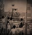
**Cover image.** Agence Rol press negative, 30 July 1928, Bibliothèque nationale de France via Gallica, public domain — catalogued as Cochet against Tilden, Davis Cup, reference Rol 131588. Henri Cochet stretching for a low ball on the new clay. The manual scoreboard behind the far corner reads W. T. TILDEN and H. COCHET over columns for JEUX and SETS. Note what the frame shows of the ground itself: raked bleacher stands rather than finished stands, a plain canvas sheet strung along the back wall as a sightscreen, and officials sitting on wooden boxes at the court edge. This is a venue put up quickly. Agence Rol's dates are the date the picture was circulated to newspapers, which is why some of this sequence is filed 30 July although the tie finished on the 29th; the reference numbers and reversed annotations visible in the emulsion are the agency's own.
**Second image.** Agence Rol press negative, 28 July 1928, BnF via Gallica, public domain — Cochet and Borotra in the doubles, reference Rol 131534. The far stand is in full view: timber cross-bracing, spectators standing on the framework, and the roofs of Auteuil beyond it.









































 expand_more